Is there a better way to learn the landscape of a country other than to walk it?
RK has been mentioning walking to Kolar, doing a walking trip to Tirupathi from Bangalore and other such ideas for many years and I was not in the mental frame of mind to pursue it with any great interest.
Since last year, after we camped out so often in our farm, come rain or shine, my comfort with the outdoors has grown. I feel as though I personally can handle the weather, no matter how rainy or hot it gets.
Multiple conversations during the course of our Sikkim trip and a chance meeting with Mr. Abdul, who is walking from Thrissur, Kerala to Bangladesh through Nepal and Bhutan, allowed me to think through the individual steps of the overall idea and and realize, once you break down the seeming insanity of walking everywhere, regardless of its distance, into bite-sized steps, then it not only becomes manageable, but downright exciting.
To put this new found realization to reality, on our last couple of days in Sikkim, we decided to walk from Yuksom. We initially meant to walk all the way to Jorethang, from where we would take a cab to Siliguri and thence a train to Varanasi. But Jorethang is almost 62kms away and we didn't think we would be able to manage that far in one day. Hence, we decided to walk from Yuksom to Tashideng after sending our luggage by jeep from Yuksom to Jorethang, Armed with a couple of bags containing food and water, the four of us set out to shatter our mental barriers against long distance walking.
Tashiding probably has the most famous monastry in Sikkim. The monastry, while not as old as Dubdi in Yuksom, is considered to be sort of like a Thirthasthala: a place where you are reborn and your soul is cleaned of all its sins. Many pilgrims make the journey to Tashiding. We felt confident that we might be able to get a cab from there to Jorethang.
 |
| The route from Yuksom to Tashiding |
 |
| Position of Tashiding relative to Yuksom and Jorethang, Sikkim |
Our landlady at Yuksom, Mrs. Bhutia, sent us off with hot tea and best wishes.
RK, in one of his occasionally autocratic decrees, herded us into a huddle before we started to lay down some ground rules:
1. We would walk in a single file,
2. We would not suddenly stop walking even if there was something extremely interesting, and
3. We wouldn't whine for breaks.
We saluted, "Sir, yes sir!" and began. Ani was jubilant because he assumed that just because Yuksom was high up in the mountains, walking to any point south of Yuksom meant that we would only walk downhill from it. Neither RK nor I disabused him of that notion to preemptively stave off any whining.
For the first couple of hours, the route was all downhill. Durga made friends with stray dogs, we came across extremely pretty wild flowers, there were many streams with clean mountain water that trickled down. The air was crisp and slightly cold. Occasionally we would see some villager, lounging by the side of the road. Some had pet dogs that Durga would befriend and they would ask us, "Where are you off to?"
.jpeg) |
| A few minutes after we start from Yuksom, Durga breaks rule 2 (and she knows it, by the grin on her face). |
 |
| Trickles of water from the mountain are tapped into bamboo shoots and become a natural tap. Many travelers use this for bathing, washing and drinking |
.jpeg) |
| These streams are extremely refreshing, cold and clean- perfect to cool down after a few hours of walking |
 |
| Our first and favorite hill (because we could walk entirely downhill) was closest to Yuksom and had many tiny waterfalls like this one. |
About two hours after leaving Yuksom, we reached Phamrong Falls. We were hungry by this time and fell eagerly onto the packs of aloo parathas and pickle we had picked up in Yuksom. The mountain water was also safe enough to drink: these were mountains higher up, with very few human settlements nearby; these waterfalls were not easy for either humans or animals to climb and poop or pee into. Lower down, however, we would have to figure out an alternate water solution, maybe beg some from villagers.
The downhill bit soon gave rise to steep up-hills, which never seemed to climb down. Up and up and up we went; the sun beat down mercilessly and the beautiful forests near Yuksom gave way to many road and building construction projects and larger numbers of vehicles plying on the highway. We took multiple breaks by the side of the road and the initial enthusiasm was giving way to a sense of despair: "How many hours of this, Appa?" demanded the kids. "It's so hot and it's so hard to walk!"
But we persevered. Walking makes it easy to find objects to stare at or remember stories to entertain. The kids were distracted by the sight of small wildflowers clinging to the side of rocks or oddly shaped leaves or the call of birds we had never seen before, like the booted eagle.
The booted eagle is apparently found through all of India, though this was the first time we have ever caught a glimpse of it. One can hear it before one sees it. And on that hot road with construction dust all around us, the cries of these birds came as a welcome surprise. The "ki-ki-ki-hyaah" shriek is loud, repetitive and attention-grabbing. Ani took the Collins' bird guide and figured out the identity based on its cry and flight pattern.
 |
| From https://ebird.org/species/booeag1?siteLanguage=en_IN showing the reported distribution of the Booted Eagle |
Walking in a single file up and down hills reminded Durga and me of the stories from the Ramayana. Lakshmana is supposed to have observed the backs of the heels of Sita as they walked (also in single file!) through the jungles of India. RK and I have had multiple interesting discussions on whether peninsular India was always truly thickly forested, as we imagine from Amar Chitra Katha books, or whether there were always dry scrub/deciduous forests instead. It's hard to imagine places like Hampi, for instance, being anything different, landscape-wise, than it is today: could there really have been thick forests in that rocky region?
About 10km from Tashiding, we ran out of water. I heard voices on the hill above and walked up to find a hut. There was one (slightly drunk) guy with his sister. I asked them for hot water and he demanded Rs. 20/ I paid up, although his sister hissed next to him, "We never charge for water!" Nevertheless, he showed us the road to Tashiding (supposedly a shortcut, though it looked exactly the same as on Google maps!), talked volubly and expansively about the benefits of walking and said he himself would be taking a car that way!
 |
| Kids sitting by the side of the road waiting for me to get water from a nearby hut |
Some where on the way, we met a party of brightly colored minivets- a flock of male and female scarlet minivets flew over our heads and roosted in a tree right ahead. Against a blue sky and a stark brown mountain, their bright red and yellow colors came as a breath-catching shock. We couldn't contain our excitement- what a marvelous treat!
From shutterstock. Male and female minivets. Just look at that red and yellow!
Soon afterwards, the road split into two: one uphill and one downhill. Needless to say, we all gravitated towards the one going downhill. Thankfully it also ended up being the road towards Tashiding town. Most surprisingly, the slightly drunk guy from before turned up in a car going in the opposite direction and confirmed that the downhill road indeed was going to Tashiding! How he turned up there at exactly that time, that too from the opposite direction, I have no idea.
.jpeg) |
| Durga entertains herself by finding various twigs that she claims are wands. |
.jpeg) |
| Tashiding Town |
 |
| Down, down, down! |
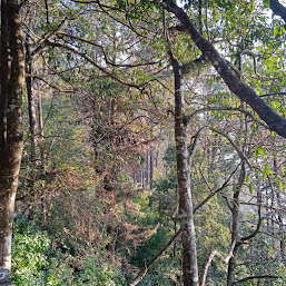
 |
| Forests on either side of the road to Tashiding. |
About 6 -6.5 hours after we left, we grabbed a cab from Tashiding and reached Jorethang. It was a good walk, hardly as tiring as we feared. Quite productive too, since both RK and I handled work calls while on it. It taught the kids grit, it taught us that we can easily handle long distance walking and it gave an insight into how our ancestors might have walked from continent to continent, with bag, baggage and children.


.jpeg)

.jpeg)


.jpeg)
.jpeg)